Image:Eu cartogram.png
From Wikipedia, the free encyclopedia
No higher resolution available.
Eu_cartogram.png (490 × 436 pixels, file size: 10 KB, MIME type: image/png)
| | This is a file from the Wikimedia Commons. The description on its description page there is shown below.
|
[edit] Summary
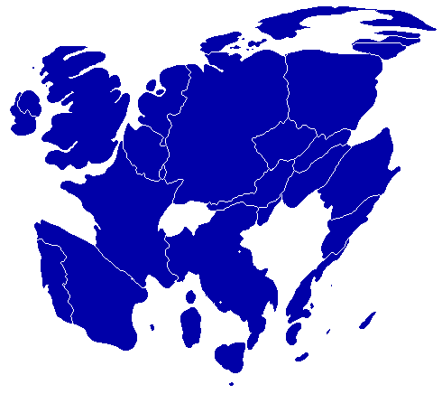
| Description |
A cartogram depicting population distribution within the European Union at the member state level. Note how roughly half of all citizens within the EU live within the 4 largest member states: Germany, France, United Kingdom, and Italy. |
|---|---|
| Source |
Self-made, referenced from a similiar cartogram at worldmapper.net |
| Date |
Mar 27th, 08 |
| Author | |
| Permission (Reusing this image) |
Any one may use this image. |
[edit] Licensing
| I, the copyright holder of this work, hereby release it into the public domain. This applies worldwide. In case this is not legally possible: Afrikaans | Alemannisch | Aragonés | العربية | Asturianu | Български | Català | Česky | Cymraeg | Dansk | Deutsch | Eʋegbe | Ελληνικά | English | Español | Esperanto | Euskara | Estremeñu | فارسی | Français | Galego | 한국어 | हिन्दी | Hrvatski | Ido | Bahasa Indonesia | Íslenska | Italiano | עברית | Kurdî / كوردی | Latina | Lietuvių | Latviešu | Magyar | Македонски | Bahasa Melayu | Nederlands | Norsk (bokmål) | Norsk (nynorsk) | 日本語 | Polski | Português | Ripoarisch | Română | Русский | Shqip | Slovenčina | Slovenščina | Српски / Srpski | Svenska | ไทย | Tagalog | Türkçe | Українська | Tiếng Việt | Walon | 中文(简体) | 中文(繁體) | zh-yue-hant | +/- |
File history
Click on a date/time to view the file as it appeared at that time.
| Date/Time | Dimensions | User | Comment | |
|---|---|---|---|---|
| current | 09:54, 27 March 2008 | 490×436 (10 KB) | Geoilex | ({{Information |Description= A cartogram depicting population distribution within the European Union at the member state level. Note how roughly half of all citizens within the EU live within the 4 largest member states: Germany, France, United Kingdom, an) |
| 09:47, 27 March 2008 | 490×436 (10 KB) | Geoilex | ({{Information |Description= A cartogram depicting population distribution within the European Union and the member state level. Note how roughly half of all citizens within the EU live within the 4 largest member states: Germany, France, United Kingdom, a) |

