Image:Ethnographic Iberia 200 BCE.PNG
From Wikipedia, the free encyclopedia
Size of this preview: 644 × 599 pixels
Full resolution (677 × 630 pixels, file size: 44 KB, MIME type: image/png)
| | This is a file from the Wikimedia Commons. The description on its description page there is shown below.
|
[edit] Summary
| Description |
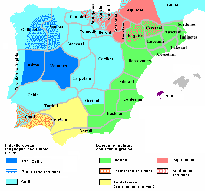
Ethnographic and Linguistic Map of the Iberian Peninsula at about 200 BCE (at the end of the Second Punic War). Based on the map done by Portuguese Archeologist Luís Fraga (luisfraga@arqueotavira.com), from the "Campo Arqueológico de Tavira" (Tavira Archeological Camp - official site), in Tavira, Algarve - Portugal. The reference map can be found at this location, and a pdf version, with extensive and detailed information on the criteria used, as well as the long bibliography used to source the map can be found here. |
|---|---|
| Source |
self-made from Image:Blank-peninsula Iberica.png |
| Date |
28 February 2008 |
| Author | |
| Permission (Reusing this image) |
see below |
[edit] Licensing

File history
Click on a date/time to view the file as it appeared at that time.
| Date/Time | Dimensions | User | Comment | |
|---|---|---|---|---|
| current | 07:11, 9 March 2008 | 677×630 (44 KB) | The Ogre | (Still another correction for the Baleares) |
| 11:51, 8 March 2008 | 677×630 (44 KB) | The Ogre | (Small corrections) | |
| 07:05, 29 February 2008 | 677×630 (43 KB) | The Ogre | (Fixed minor graphical tweak) | |
| 10:33, 28 February 2008 | 677×630 (43 KB) | The Ogre | (Changed Proto-Celtic to Pre-Celtic and increased the area for the Aquitanian language) | |
| 04:46, 28 February 2008 | 677×630 (43 KB) | The Ogre | ({{Information |Description=Ethnographic and Linguistic Map of the Iberian Peninsula at about 200 BCE (at the end of the Second Punic War). Based on the map done by Portuguese Archeologist Luís Fraga (luis) |
File links
The following pages on the English Wikipedia link to this file (pages on other projects are not listed):
- Celts
- Iberian Peninsula
- Portugal
- History of Portugal
- Iberians
- List of Celtic tribes
- Celtiberians
- Hispania
- Lusitanians
- Portuguese people
- Cynetes
- Aquitanian language
- Celtici
- Gallaeci
- Languages of Iberia
- Celtic nations
- Languages of Portugal
- Pre-Roman peoples of the Iberian Peninsula
- Paleohispanic languages
- User:The Ogre/Images
- List of Celtic place names in Portugal
- User:Sasha l/DNA/R

