Image:EnglandTameside.png
From Wikipedia, the free encyclopedia
No higher resolution available.
EnglandTameside.png (200 × 247 pixels, file size: 30 KB, MIME type: image/png)
| | This is a file from the Wikimedia Commons. The description on its description page there is shown below.
|
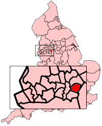
Metropolitan borough of Tameside in Greater Manchester
Map created by Morwen

File history
Click on a date/time to view the file as it appeared at that time.
| Date/Time | Dimensions | User | Comment | |
|---|---|---|---|---|
| current | 22:16, 29 October 2007 | 200×247 (30 KB) | Jhamez84 | (removed white space around map) |
| 23:36, 30 May 2006 | 200×247 (27 KB) | Nichtbesserwisser | (Metropolitan borough of Tameside in Greater Manchester Map created by Morwen {{GFDL}} Category:Maps of England) |
File links
The following pages on the English Wikipedia link to this file (pages on other projects are not listed):

