Image:EasternRomanEmpire.png
From Wikipedia, the free encyclopedia
No higher resolution available.
EasternRomanEmpire.png (250 × 175 pixels, file size: 7 KB, MIME type: image/png)
| | This is a file from the Wikimedia Commons. The description on its description page there is shown below.
|
 |
This map has been uploaded by Electionworld from en.wikipedia.org to enable the |
|
|
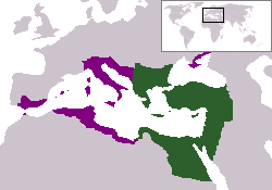
The territory in green represents the core areas held by the Eastern Roman Empire before the Muslim conquests The territory in purple represents the greatest extent of the Byzantine Empire under Emperor Justinian I
File history
Click on a date/time to view the file as it appeared at that time.
| Date/Time | Dimensions | User | Comment | |
|---|---|---|---|---|
| current | 18:27, 13 December 2006 | 250×175 (7 KB) | Electionworld | ({{ew|en|24630}} {{CopyrightedFreeUse-User|24630}} The territory in green represents the core areas held by the Eastern Roman Empire before the Muslim conquests The territory in purple represents the greatest extent of the Byzantine Empire unde) |
File links
The following pages on the English Wikipedia link to this file (pages on other projects are not listed):

