Image:Dundon Camp Somerset Map.jpg
From Wikipedia, the free encyclopedia
Size of this preview: 391 × 600 pixels
Full resolution (600 × 920 pixels, file size: 92 KB, MIME type: image/jpeg)
| | This is a file from the Wikimedia Commons. The description on its description page there is shown below.
|
[edit] Summary
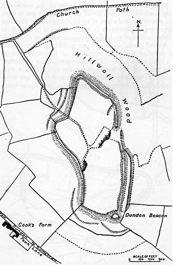
| Description |
Map of earthworks at Compton Dundon, Somerset, England. |
|---|---|
| Source |
The Victoria History of the Counties of England, A History Of Somerset, Volume 2. |
| Date |
1911 |
| Author |
Editor - W.Page; Chapter on Ancient Earthworks - C.H.Bothamley |
| Permission (Reusing this image) |
Copyright has expired in the United Kingdom, and is believed to be in the public domain. |
[edit] Licensing
| This image (or other media file) is in the public domain because its copyright has expired. This applies to the United States, Canada, the European Union and those countries with a copyright term of life of the author plus 70 years.
العربية | Asturianu | Български | Català | Česky | Dansk | Deutsch | English | Ελληνικά | Esperanto | Español | Euskara | فارسی | Français | Gaeilge | Galego | עברית | हिन्दी | Bahasa Indonesia | Italiano | 日本語 | 한국어 | Kurdî / كوردی | Lietuvių | Magyar | Nederlands | Norsk (nynorsk) | Bahasa Melayu | Polski | Português | Română | Русский | Slovenčina | Slovenščina | Shqip | Suomi | Sámegiella | Türkçe | 中文(简体) | 中文(繁體) | 粵語 | +/- |
File history
Click on a date/time to view the file as it appeared at that time.
| Date/Time | Dimensions | User | Comment | |
|---|---|---|---|---|
| current | 22:15, 13 December 2006 | 600×920 (92 KB) | Mikhailfranco | ({{Information |Description=Map of earthworks at Compton Dundon, Somerset, England. |Source=The Victoria History of the Counties of England, A History Of Somerset, Volume 2. |Date=1911 |Author=Editor - W.Page; Chapter on Ancient Earthworks - C.H.Bothamley ) |

