Image:Donau-Karte.png
From Wikipedia, the free encyclopedia
Size of this preview: 800 × 352 pixels
Full resolution (1,024 × 451 pixels, file size: 65 KB, MIME type: image/png)
| | This is a file from the Wikimedia Commons. The description on its description page there is shown below.
|
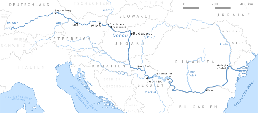
Map of the Danube
- The Map shows the european river Danube
- "drawn" by myself, Daniel Ullrich (Threedots) with Adobe Photoshop 6.0 in February 2005
- If you ask for, I will give you the .psd- / .xfc-file or I'll correct it or create another language version
Karte der Donau
- Die Karte zeigt den europäischen Fluss Donau
- von mir selbst, Daniel Ullrich (Threedots) im Februar 2005 mit Adobe Photoshop 6.0 "gezeichnet"
- Auf Anfrage stelle ich gern die .psd- / .xfc-Datei bereit oder erstelle selbst korrigierte oder andersprachige Versionen

File history
Click on a date/time to view the file as it appeared at that time.
| Date/Time | Dimensions | User | Comment | |
|---|---|---|---|---|
| current | 01:08, 15 February 2005 | 1,024×451 (65 KB) | Threedots | (small fixes (swamp in delta-area, city-names...)) |
| 23:37, 14 February 2005 | 1,024×451 (65 KB) | Threedots | (Map of the european river Danube {{GFDL}}) |
File links
The following pages on the English Wikipedia link to this file (pages on other projects are not listed):

