Image:Dokdo Map.png
From Wikipedia, the free encyclopedia
Size of this preview: 657 × 600 pixels
Full resolution (748 × 683 pixels, file size: 9 KB, MIME type: image/png)
| | This is a file from the Wikimedia Commons. The description on its description page there is shown below.
|
La bildo estas kopiita de wikipedia:en. La originala priskribo estas:
[edit] Summary
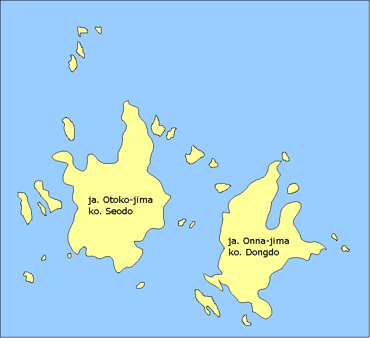
- Description: Map of the Liancourt Rocks, showing the two main islets and some of the minor ones.
- Source: Drawn myself.
[edit] Licensing

| date/time | username | edit summary |
|---|---|---|
| 11:10, 9 January 2006 | en:User:Kokiri | (*Description: Map of the <a href="/wiki/Liancourt_Rocks" title="Liancourt Rocks">Liancourt Rocks</a>, showing the two main islets and some of the minor ones. *Source: Drawn myself.) |
| 2006-07-23 (en WP) 2006-07-30 12:13 (Commons) |
en:User:Bkell (User:Bkell) |
removed "Wikipedia" in lower right-hand corner, reduced color depth to 16 colors |
[edit] Historio de la dosiero
Legend: (cur) = this is the current file, (del) = delete this old version, (rev) = revert to this old version.
Click on date to download the file or see the image uploaded on that date.
- (del) (cur) 11:10, 9 January 2006 . . en:User:Kokiri Kokiri ( en:User_talk:Kokiri Talk) . . 748x683 (80856 bytes) (*Description: Map of the en:Liancourt_Rocks Liancourt Rocks, showing the two main islets and some of the minor ones. *Source: Drawn myself.)
File history
Click on a date/time to view the file as it appeared at that time.
| Date/Time | Dimensions | User | Comment | |
|---|---|---|---|---|
| current | 12:13, 30 July 2006 | 748×683 (9 KB) | Dustsucker | (Bkell has removed "Wikipedia" in lower right-hand corner and has reduced color depth to 16 colors) |
| 20:35, 22 January 2006 | 748×683 (79 KB) | Maksim | (La bildo estas kopiita de wikipedia:en. La originala priskribo estas: == Summary == *Description: Map of the Liancourt Rocks, showing the two main islets and some of the minor ones. *Source: Drawn myself. == Licensing == {{GFDL-self}} {| border="1" ) |
File links
The following pages on the English Wikipedia link to this file (pages on other projects are not listed):

