Image:Docklands-map.jpg
From Wikipedia, the free encyclopedia
No higher resolution available.
Docklands-map.jpg (490 × 224 pixels, file size: 22 KB, MIME type: image/jpeg)
| | This is a file from the Wikimedia Commons. The description on its description page there is shown below.
|
| Description |
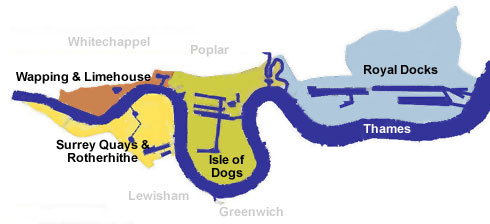
Areas of the London Docklands |
|---|---|
| Source |
Originally from en.wikipedia; description page is/was here. |
| Date |
2005-08-09 (original upload date) |
| Author |
Original uploader was Se16boy at en.wikipedia |
| Permission (Reusing this image) |
Released under the GNU Free Documentation License. |
[edit] License information

[edit] Original upload log
(All user names refer to en.wikipedia)
- 2005-08-09 21:56 Se16boy 490×224×8 (22804 bytes) {{GFDL}} Areas of the London Docklands
File history
Click on a date/time to view the file as it appeared at that time.
| Date/Time | Dimensions | User | Comment | |
|---|---|---|---|---|
| current | 15:17, 9 December 2006 | 490×224 (22 KB) | Voyager | (Areas of the London Docklands Map originally uploaded on en: by Se16boy {{GFDL}} Category:Maps of London) |
File links
The following pages on the English Wikipedia link to this file (pages on other projects are not listed):

