Image:Democratic Republic of Georgia map.jpg
From Wikipedia, the free encyclopedia
Size of this preview: 800 × 561 pixels
Full resolution (1,213 × 850 pixels, file size: 111 KB, MIME type: image/jpeg)
| | This is a file from the Wikimedia Commons. The description on its description page there is shown below.
|
 It is recommended that the other file be used. Alemannisch | العربية | Български | Česky | Dansk | Deutsch | English | Ελληνικά | Esperanto | Español | Français | Galego | עברית | हिन्दी | Magyar | Bahasa Indonesia | Italiano | 日本語 | 한국어 | Lietuvių | Nederlands | Norsk (nynorsk) | Polski | Português | Română | Русский | Slovenščina | Српски / Srpski | Svenska | Türkçe | 中文(简体) | 中文(繁體) | +/- |
[edit] Summary
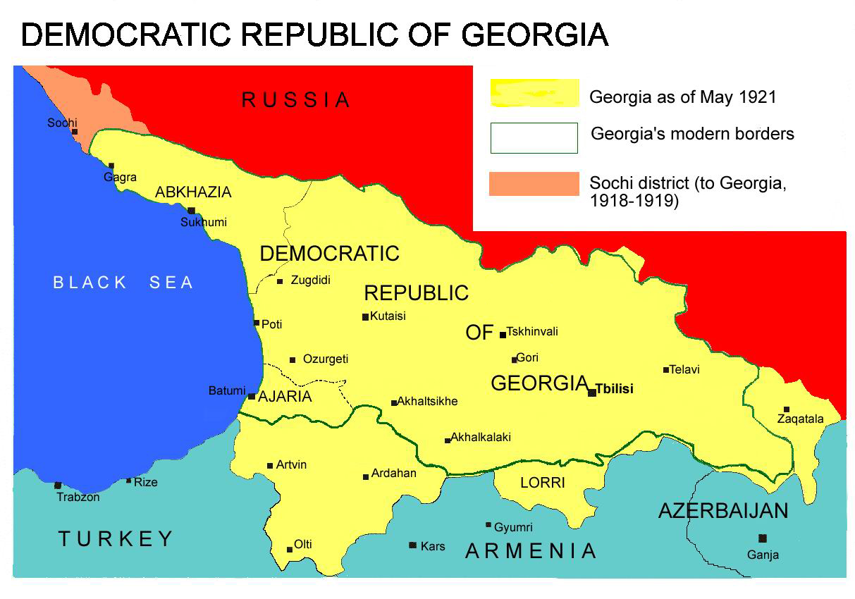
Democratic Republic of Georgia map, 1918-1921
Source: english wikipedia
Uploaded by user:Kober
[edit] Licensing
| I, the copyright holder of this work, hereby release it into the public domain. This applies worldwide. In case this is not legally possible: Afrikaans | Alemannisch | Aragonés | العربية | Asturianu | Български | Català | Česky | Cymraeg | Dansk | Deutsch | Eʋegbe | Ελληνικά | English | Español | Esperanto | Euskara | Estremeñu | فارسی | Français | Galego | 한국어 | हिन्दी | Hrvatski | Ido | Bahasa Indonesia | Íslenska | Italiano | עברית | Kurdî / كوردی | Latina | Lietuvių | Latviešu | Magyar | Македонски | Bahasa Melayu | Nederlands | Norsk (bokmål) | Norsk (nynorsk) | 日本語 | Polski | Português | Ripoarisch | Română | Русский | Shqip | Slovenčina | Slovenščina | Српски / Srpski | Svenska | ไทย | Tagalog | Türkçe | Українська | Tiếng Việt | Walon | 中文(简体) | 中文(繁體) | zh-yue-hant | +/- |
File history
Click on a date/time to view the file as it appeared at that time.
| Date/Time | Dimensions | User | Comment | |
|---|---|---|---|---|
| current | 16:46, 26 December 2005 | 1,213×850 (111 KB) | Hardscarf | (Democratic Republic of Georgia map, 1918-1921 Source: [http://en.wikipedia.org/wiki/Image:Democratic_Republic_of_Georgia_map.jpg english wikipedia] Uploaded by [http://en.wikipedia.org/wiki/User:Kober user:Kober] Category:Historical maps of Georgia) |
File links
Metadata
This file contains additional information, probably added from the digital camera or scanner used to create or digitize it. If the file has been modified from its original state, some details may not fully reflect the modified file.
| Orientation | Normal |
|---|---|
| Software used | ACD Systems Digital Imaging |
| File change date and time | 12:50, 21 December 2005 |
| Y and C positioning | 1 |
| Exif version | 2.1 |
| DateTime subseconds | 515 |

