Image:Danubemap.png
From Wikipedia, the free encyclopedia
No higher resolution available.
Danubemap.png (747 × 480 pixels, file size: 601 KB, MIME type: image/png)
| | This is a file from the Wikimedia Commons. The description on its description page there is shown below.
|
[edit] Summary
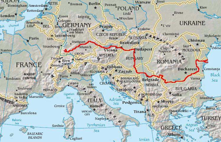
Map showing the flow of the Danube River. Uses the map of Europe from the CIA World Factbook.
[edit] Licensing
| This work is in the public domain in the United States because it is a work of the United States Federal Government under the terms of Title 17, Chapter 1, Section 105 of the US Code. See Copyright.
Note: This only applies to works of the Federal Government and not to the work of any individual U.S. state, territory, commonwealth, county, municipality, or any other subdivision. العربية | Български | Česky | Deutsch | English | Español | Français | Magyar | Italiano | 日本語 | 한국어 | Polski | Português | 中文(繁體) | 中文(简体) | +/- |
 |
File history
Click on a date/time to view the file as it appeared at that time.
| Date/Time | Dimensions | User | Comment | |
|---|---|---|---|---|
| current | 05:34, 12 February 2007 | 747×480 (601 KB) | Geologik | (Map showing the flow of the Danube River. Uses the map of Europe from the CIA World Factbook.) |
File links
The following pages on the English Wikipedia link to this file (pages on other projects are not listed):
- Bratislava
- Geography of Bulgaria
- Geography of Croatia
- Danube
- Geography of Germany
- Geography of Hungary
- Geography of Moldova
- Geography of Romania
- Geography of Slovakia
- Serbia
- Geography of Ukraine
- Budapest
- Regensburg
- Tisza
- Linz
- Vienna
- Belgrade
- Vedea River
- Geography of Austria
- Novi Sad
- Vukovar
- Drava
- Ulm
- Lech River
- Iller
- Inn River
- Ingolstadt
- Passau
- Regen River
- Isar
- Galaţi
- Jiu River
- Rousse
- Bačka Palanka
- Smederevo
- Vidin
- Prut
- Brăila
- Geography of Serbia
- Váh
- Hron
- Cernavodă
- Tulcea
- Drobeta-Turnu Severin
- Sulina
- Krems an der Donau
- Sava River
- Győr
- Corabia
- Esztergom
- Morava River
- Baja, Hungary
- Great Morava
- Ipeľ
- Vit
- Donaueschingen
- Yantra River
- Osam
- Karaš River
- Iskar
- Nera River (Danube)
- Ilok
- Template:Danube
- List of tributaries of the Danube
- Cerna River (Danube)
- User:MarkBA/Sandbox
- Luncaviţa River (Danube)
- List of crossings of the Danube River

