Image:Cyprus districts named.png
From Wikipedia, the free encyclopedia
No higher resolution available.
Cyprus_districts_named.png (600 × 365 pixels, file size: 22 KB, MIME type: image/png)
| | This is a file from the Wikimedia Commons. The description on its description page there is shown below.
|
| Description |
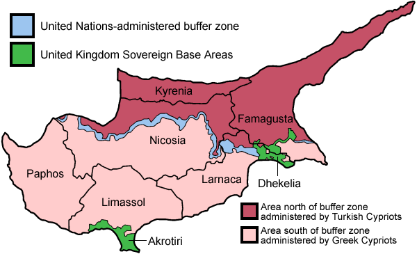
Map of the districts of Cyprus, named in English, with English annotations, and showing the Turkish Republic of Northern Cyprus, United Kingdom Sovereign Base Areas, and United Nations buffer zone. The individual maps are: |
|---|---|
| Source |
Self-made, traced from public domain UN or CIA maps. |
| Date |
June 2005 |
| Author | |
| Permission (Reusing this image) |
Provide attribution, please. See below. |
| Other versions |
Français :
http://commons.wikimedia.org/wiki/Image:Carte_des_districts_de_Chypre.png |

File history
Click on a date/time to view the file as it appeared at that time.
| Date/Time | Dimensions | User | Comment | |
|---|---|---|---|---|
| current | 14:28, 13 August 2007 | 600×365 (22 KB) | Lexicon | (Reverted to earlier revision) |
| 14:28, 13 August 2007 | 600×365 (54 KB) | Lexicon | (buffer zone and SBA colours flipped, since buffer zone is called the "Green Line") | |
| 06:07, 30 June 2005 | 600×365 (22 KB) | Golbez | (Got Dhekelia wrong again. Final version unless others have comments.) | |
| 02:04, 28 June 2005 | 600×365 (22 KB) | Golbez | (Updated again, final version for now, cleaned up text and the Dhekelia area.) | |
| 17:51, 27 June 2005 | 600×365 (20 KB) | Golbez | (Fixed a color) | |
| 17:44, 27 June 2005 | 600×365 (20 KB) | Golbez | (Updated map with different color for north and south, and enclaves in Dhekelia.) | |
| 09:48, 27 June 2005 | 600×365 (19 KB) | Golbez | (Map of the districts of Cyprus Source: Made by User:Golbez. {{cc-by-sa-2.0}} Category:Maps of Cyprus\) |
File links
The following pages on the English Wikipedia link to this file (pages on other projects are not listed):
- Cyprus
- Cyprus dispute
- Megali Idea
- Separation barrier
- United Nations Buffer Zone in Cyprus
- Turkish Cypriots
- Greek Cypriots
- Wikipedia:Featured picture candidates/Cyprus districts named
- Wikipedia:Featured picture candidates/July-2005
- Districts of Cyprus
- User:Mgekelly/Where
- Turkish Military Forces in Northern Cyprus
- Military history of Turkey
- Gallery of current first-level administrative country subdivisions maps

