Image:CrossHarborRailFacilityMap.png
From Wikipedia, the free encyclopedia
No higher resolution available.
CrossHarborRailFacilityMap.png (415 × 349 pixels, file size: 15 KB, MIME type: image/png)
[edit] Summary
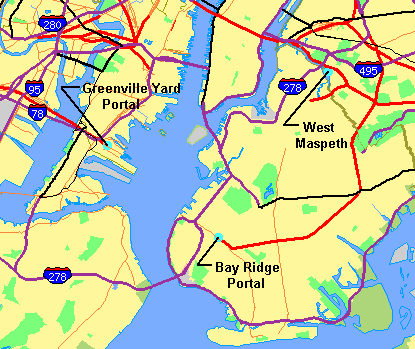
Map showing New York Harbor with adjacent parts of New York and New Jersey obtained from U.S. Census Bureau, with facilities of proposed Cross-Harbor Rail Tunnel shown on map by Cross Harbor Freight Movement Project superimposed and legends added by hand. Mainly work of a U.S. government agency. The base map is from the US Census TIGER map browser, and is public domain.
[edit] Licensing
| This work is in the public domain in the United States because it is a work of the United States Federal Government under the terms of Title 17, Chapter 1, Section 105 of the US Code. See Copyright. Note: This only applies to works of the Federal Government and not to the work of any individual U.S. state, territory, commonwealth, county, municipality, or any other subdivision. |
 |
File history
Click on a date/time to view the file as it appeared at that time.
| Date/Time | Dimensions | User | Comment | |
|---|---|---|---|---|
| current | 18:27, 21 May 2006 | 415×349 (15 KB) | Craig Bolon (Talk | contribs) | (Map showing New York Harbor with adjacent parts of New York and New Jersey obtained from U.S. Census Bureau, with facilities of proposed Cross-Harbor Rail Tunnel shown on map by Cross Harbor Freight Movement Project superimposed and legends added by hand.) |
| 16:31, 21 May 2006 | 415×349 (15 KB) | Craig Bolon (Talk | contribs) | (Map showing New York Harbor with adjacent parts of New York and New Jersey obtained from U.S. Census Bureau, with facilities of proposed Cross-Harbor Rail Tunnel shown on map by Cross Harbor Freight Movement Project superimposed and legends added by hand.) |
- Search for duplicate files
- Edit this file using an external application
See the setup instructions for more information.
File links
The following pages on the English Wikipedia link to this file (pages on other projects are not listed):

