Image:Crete location map.png
From Wikipedia, the free encyclopedia
No higher resolution available.
Crete_location_map.png (328 × 500 pixels, file size: 39 KB, MIME type: image/png)
| | This is a file from the Wikimedia Commons. The description on its description page there is shown below.
|
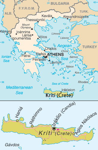
Map of Crete. Adapted from [1]
| This image is in the public domain because it contains materials that originally came from the United States Central Intelligence Agency's World Factbook.
Deutsch | English | Español | Français | 日本語 | Nederlands | 한국어 | Português | தமிழ் | Magyar | +/- |
 |
| This image is a mapping derived from products of the United Nations Cartographic Section. Modified versions of UNCS maps may be used provided that the UN name and reference number does not appear on any modified version and a link to the original map is provided. Modified UN maps are to be considered in the public domain. This applies worldwide The UN maps is an open source material. You can use them to make your own maps. You do not need our permission for that. Please be advised that the UN name and reference number should not appear on any modified map. The UN map is a UN document and cannot be modified. You can say something like "Based on UN map number..." -- Vladimir Bessarabov (UNCS Cartographer), 13 April 05 |
 |
File history
Click on a date/time to view the file as it appeared at that time.
| Date/Time | Dimensions | User | Comment | |
|---|---|---|---|---|
| current | 08:59, 14 February 2006 | 328×500 (39 KB) | *drew | (Map of Crete, Greece. Taken from En Wikipedia {{PD-USGov-CIA-WF}} Category:Crete) |
File links
No pages on the English Wikipedia link to this file. (Pages on other projects are not counted.)

