Image:CornwallKerrier.png
From Wikipedia, the free encyclopedia
No higher resolution available.
CornwallKerrier.png (200 × 191 pixels, file size: 11 KB, MIME type: image/png)
| | This is a file from the Wikimedia Commons. The description on its description page there is shown below.
|
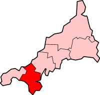
Kerrier in Cornwall
Created by en:User:Morwen, uploaded on 31 January 2004

File history
Click on a date/time to view the file as it appeared at that time.
| Date/Time | Dimensions | User | Comment | |
|---|---|---|---|---|
| current | 01:55, 26 February 2006 | 200×191 (11 KB) | QuartierLatin1968 | (Kerrier in Cornwall From en:Image:CornwallKerrier.png by en:User:Morwen {{GFDL-en}} Category:Maps of English districts Category:Maps of Cornwall ) |
File links
The following pages on the English Wikipedia link to this file (pages on other projects are not listed):
- Redruth
- Camborne
- Helston
- Kerrier
- St Keverne
- Carn Brea
- Porthleven
- Carharrack
- Gweek
- Stithians
- Budock Water
- St Day
- Gunwalloe
- Constantine, Kerrier
- Breage, Cornwall
- Mullion, Cornwall
- Portreath
- Illogan
- Mawnan
- Manaccan
- Template:Kerrier navigation box
- Crowan
- Cury
- Germoe
- Grade-Ruan
- Landewednack
- Lanner, Cornwall
- Mawgan-in-Meneage
- St Anthony-in-Meneage
- St Gluvias
- St Martin-in-Meneage
- Sithney
- Wendron
- Mabe, Cornwall
- Helston Folk Museum
- Poldark Mine

