Image:Connecticut population map.png
From Wikipedia, the free encyclopedia
No higher resolution available.
Connecticut_population_map.png (700 × 450 pixels, file size: 34 KB, MIME type: image/png)
| | This is a file from the Wikimedia Commons. The description on its description page there is shown below.
|
 |
This image was moved to Wikimedia Commons from en.wikipedia using a bot script. All source information is still present. It requires review because CommonSense could not categorise the image during transfer. Additionally, there may be errors in any or all of the information fields; information on this image should not be considered reliable and the image should not be used until it has been reviewed and any needed corrections have been made. Once the review has been completed, this template should be removed. For details, see below. |
| Description |
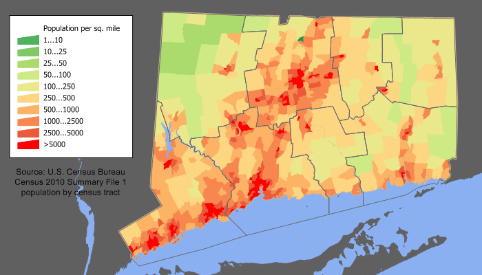
English: en:Category:U.S._State_Population_Maps
Connecticut population density map based on Census 2000. See the process description for the data lineage.
|
|---|---|
| Source |
Transferred from en.wikipedia |
| Date |
2006-02-16 (original upload date) |
| Author |
Original uploader was JimIrwin at en.wikipedia |
| Permission (Reusing this image) |
Licensed under the GFDL by the author; Released under the GNU Free Documentation License. |
[edit] License information

[edit] Original upload log
The original description page is/was here. All following user names refer to en.wikipedia.
- 2006-02-16 22:42 JimIrwin 700×450×8 (34791 bytes) Connecticut population density map based on Census 2000
File history
Click on a date/time to view the file as it appeared at that time.
| Date/Time | Dimensions | User | Comment | |
|---|---|---|---|---|
| current | 18:59, 20 April 2008 | 700×450 (34 KB) | File Upload Bot (Magnus Manske) | ( {{BotMoveToCommons|en.wikipedia}} {{Information |Description={{en|en:Category:U.S._State_Population_Maps en:Category:Connecticut maps Connecticut population density map based on Census 2000. See the [[:en:User:JimIrwin/Lineage_of_population) |

