Image:Circum-Arctic Map of Permafrost and Ground Ice Conditions.png
From Wikipedia, the free encyclopedia
Size of this preview: 534 × 599 pixels
Full resolution (683 × 766 pixels, file size: 44 KB, MIME type: image/png)
| | This is a file from the Wikimedia Commons. The description on its description page there is shown below.
|
[edit] Summary
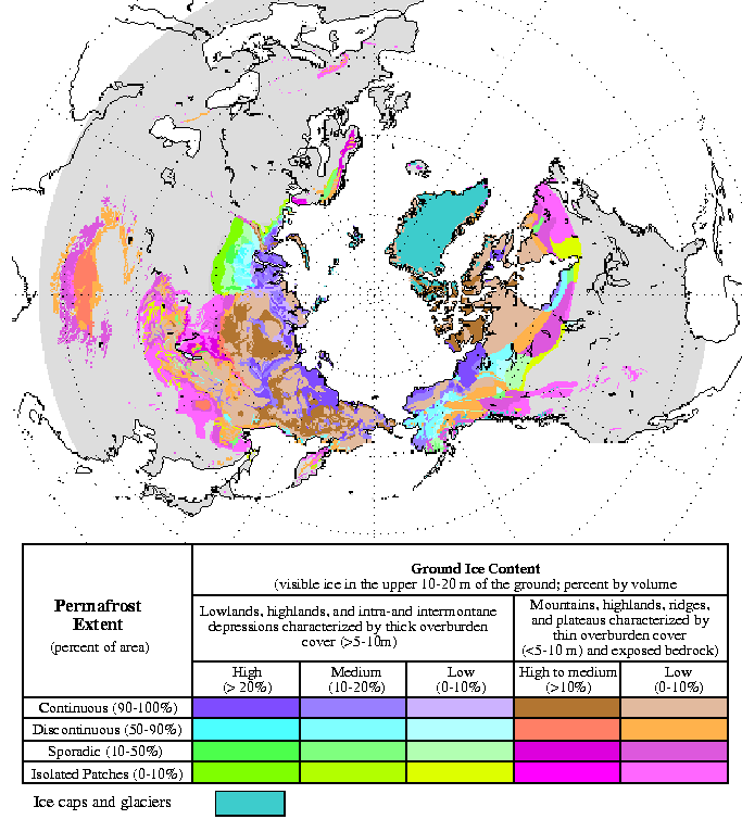
| Description |
Circum-Arctic Map of Permafrost and Ground Ice Conditions |
|---|---|
| Source |
http://nsidc.org/data/docs/fgdc/ggd318_map_circumarctic/index.html |
| Date |
1998, revised February 2001 |
| Author |
Brown, J., O.J. Ferrians, Jr., J.A. Heginbottom, and E.S. Melnikov. 1998, revised February 2001. Circum-arctic map of permafrost and ground ice conditions. Boulder, CO: National Snow and Ice Data Center/World Data Center for Glaciology |
| Permission (Reusing this image) |
see below |
[edit] Licensing:
| This work is in the public domain in the United States because it is a work of the United States Federal Government under the terms of Title 17, Chapter 1, Section 105 of the US Code. See Copyright.
Note: This only applies to works of the Federal Government and not to the work of any individual U.S. state, territory, commonwealth, county, municipality, or any other subdivision. العربية | Български | Česky | Deutsch | English | Español | Français | Magyar | Italiano | 日本語 | 한국어 | Polski | Português | 中文(繁體) | 中文(简体) | +/- |
 |
File history
Click on a date/time to view the file as it appeared at that time.
| Date/Time | Dimensions | User | Comment | |
|---|---|---|---|---|
| current | 18:40, 21 May 2008 | 683×766 (44 KB) | Sagredo | ({{Information |Description=Circum-Arctic Map of Permafrost and Ground Ice Conditions |Source=http://nsidc.org/data/docs/fgdc/ggd318_map_circumarctic/index.html |Date=1998, revised February 2001 |Author=Brown, J., O.J. Ferrians, Jr., J.A. Heginbottom, and) |

