Image:China Provincial Migration.jpg
From Wikipedia, the free encyclopedia
Size of this preview: 800 × 586 pixels
Full resolution (860 × 630 pixels, file size: 149 KB, MIME type: image/jpeg)
| | This is a file from the Wikimedia Commons. The description on its description page there is shown below.
|
 |
This map has been uploaded by Electionworld from en.wikipedia.org to enable the |
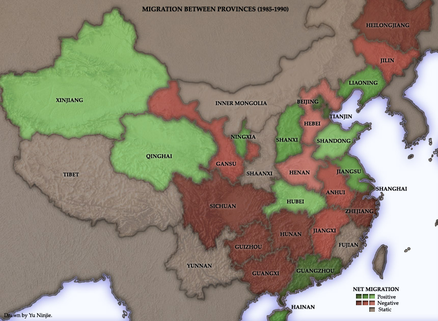
This map, of the People's Republic of China, was based on results from retrospective questions in the 1990 census.
It indicates that the six coastal provinces and municipalities of Guangdong (mislabelled on this map as Guangzhou, the name of its capital), Beijing, Shanghai, Liaoning, Tianjin, and Jiangsu had substantial net immigration from other provinces in the late 1980s. Guangdong, a centre of modernisation and industrialisation, is easily the "winner" of the 1979 communist economic reforms. Between 1985 and 1990, some 1.26 million people from other Chinese provinces migrated to this province. Only 250,000 people left Guangdong for other provinces.
Among the "losers" are Guangxi, Zhejiang, Hunan, Heilongjiang, Anhui, and Hebei - all provinces with large agricultural sectors and low economic growth.
Though this map is confined to the period 1985-1990, some of the basic outlines of interprovincial migration should still hold true.
Created and copyright (2004) by Yuninjie. Released under the GNU FDL.

File history
Click on a date/time to view the file as it appeared at that time.
| Date/Time | Dimensions | User | Comment | |
|---|---|---|---|---|
| current | 13:54, 16 December 2006 | 860×630 (149 KB) | Electionworld | ({{ew|en|Yeu Ninje}} This map, of the People's Republic of China, was based on results from retrospective questions in the 1990 census. It indicates that the six coastal provinces and municipalities of Guangdong (mislabelled on this map as [[Guangzh) |
File links
Metadata
This file contains additional information, probably added from the digital camera or scanner used to create or digitize it. If the file has been modified from its original state, some details may not fully reflect the modified file.
| Orientation | Normal |
|---|---|
| Horizontal resolution | 150 dpi |
| Vertical resolution | 150 dpi |
| Software used | Adobe Photoshop 7.0 |
| File change date and time | 20:07, 9 November 2004 |
| Color space | 65535 |

