Image:Chad regions numbered.png
From Wikipedia, the free encyclopedia
No higher resolution available.
Chad_regions_numbered.png (300 × 462 pixels, file size: 12 KB, MIME type: image/png)
| | This is a file from the Wikimedia Commons. The description on its description page there is shown below.
|
[edit] Summary
| Description |
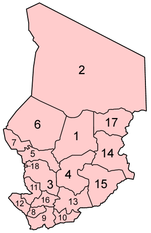
Map of the regions of Chad, numbered in English/French alphabetical order. (English = French except N'Djamena, which has a separate status, is numbered last. In French, it would be "Ville de N'Djamena", and last alphabetically.) This is the result of several days of research and staring at tiny maps, so it could still be incorrect, particularly in the southern quarter of the country. If you see any mistakes, PLEASE tell me. |
|---|---|
| Source |
Traced from various public domain maps. |
| Date |
October 2006 |
| Author | |
| Permission (Reusing this image) |
See below. |
[edit] Licensing

File history
Click on a date/time to view the file as it appeared at that time.
| Date/Time | Dimensions | User | Comment | |
|---|---|---|---|---|
| current | 21:32, 3 October 2006 | 300×462 (12 KB) | Golbez | ({{Information |Description=Map of the regions of Chad, numbered in English/French alphabetical order. (English = French except N'Djamena, which has a separate status, is numbered last. In French, it would be "Ville de N'Djamena", and last alphabetically.)) |
File links
The following pages on the English Wikipedia link to this file (pages on other projects are not listed):

