Image:Cerrado ecoregion.jpg
From Wikipedia, the free encyclopedia
No higher resolution available.
Cerrado_ecoregion.jpg (400 × 300 pixels, file size: 100 KB, MIME type: image/jpeg)
| | This is a file from the Wikimedia Commons. The description on its description page there is shown below.
|
[edit] Summary
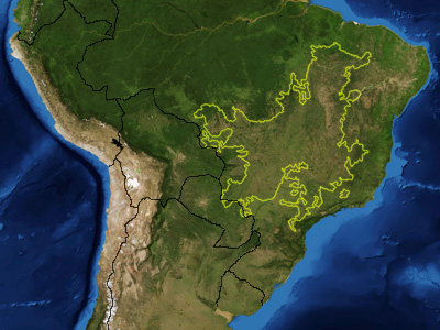
| Description |
This is a map showing the location of the Cerrado ecoregion as delineated by the World Wide Fund for Nature. I, Pfly, made it using NASA Blue Marble imagery and ecoregion GIS data which I simplified and digitized in Photoshop. |
|---|---|
| Source |
NASA, plus my additions by myself. |
| Date |
January 17, 2007 |
| Author |
Pfly |
| Permission (Reusing this image) |
see below |
[edit] Licensing
|
|
This file is in the public domain because it was created by NASA. NASA copyright policy states that "NASA material is not protected by copyright unless noted". (NASA copyright policy page or JPL Image Use Policy).
Deutsch | English | Español | Français | Nederlands | Português | Русский | 中文(简体) | 中文(繁體) | +/- |
|
 |
Warnings:
|
File history
Click on a date/time to view the file as it appeared at that time.
| Date/Time | Dimensions | User | Comment | |
|---|---|---|---|---|
| current | 05:36, 18 January 2007 | 400×300 (100 KB) | Pfly | ({{Information |Description=This is a map showing the location of the Cerrado ecoregion as delineated by the World Wide Fund for Nature. I, Pfly, made it using NASA Blue Marb) |
File links
The following pages on the English Wikipedia link to this file (pages on other projects are not listed):
Metadata
This file contains additional information, probably added from the digital camera or scanner used to create or digitize it. If the file has been modified from its original state, some details may not fully reflect the modified file.
| Orientation | Normal |
|---|---|
| Horizontal resolution | 72 dpi |
| Vertical resolution | 72 dpi |
| Software used | Adobe Photoshop CS2 Macintosh |
| File change date and time | 21:33, 17 January 2007 |
| Color space | sRGB |

