Image:CEMA members.png
From Wikipedia, the free encyclopedia
Size of this preview: 800 × 503 pixels
Full resolution (841 × 529 pixels, file size: 23 KB, MIME type: image/png)
| | This is a file from the Wikimedia Commons. The description on its description page there is shown below.
|
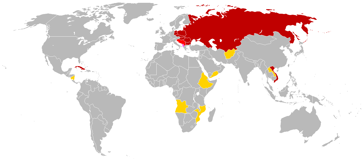
English: This is a map of the members of en:Comecon (aka the Council for Mutual Economic Assistance - CEMA). This map is based of the 1985 blank world map. The CIA World Factbook of 1991 had an profile for Comecon; this profile was used as reference. The text of the profile is below:
Council for Mutual Economic Assistance (CEMA), also known as
CMEA or Comecon, was established 25 January 1949 to promote the
development of socialist economies and was abolished 1 January 1991;
members included Afghanistan (observer), Albania (had not participated
since 1961 break with USSR), Angola (observer), Bulgaria, Cuba,
Czechoslovakia, Ethiopia (observer), GDR, Hungary, Laos (observer),
Mongolia, Mozambique (observer), Nicaragua (observer), Poland, Romania,
USSR, Vietnam, Yemen (observer), Yugoslavia (associate)
link: 1991 CIA World Factbook at the Wiretap Electronic Text Archive
Note: Even though the Factbook lists "Yemen", I think is logical to conclude that North Yemen wouldn't have joined Comecon since it wasn't communist.
€≈{{{}}}==Key==
██ members
██ members who did not participate
██ associates
██ observers
| This image has been released into the public domain by its author, Hoshie. This applies worldwide. In some countries this may not be legally possible; if so: العربية | Български | Deutsch | Ελληνικά | English | Español | Français | Italiano | 日本語 | 한국어 | Polski | Русский | Српски / Srpski | Svenska | தமிழ் | Українська | 中文(繁體) | 中文(简体) +/- |
File history
Click on a date/time to view the file as it appeared at that time.
| Date/Time | Dimensions | User | Comment | |
|---|---|---|---|---|
| current | 14:13, 21 January 2008 | 841×529 (23 KB) | Aivazovsky | ({{Information |Description= |Source= |Date= |Author= |Permission= |other_versions= }} ) |
| 13:59, 21 January 2008 | 841×529 (23 KB) | Aivazovsky | (Updated) | |
| 03:59, 29 June 2007 | 832×490 (30 KB) | Hoshie | (added Cabinda (between Angola and Zaire). under same lic. as original.) | |
| 20:49, 22 November 2006 | 832×490 (20 KB) | Hoshie | (put Albania in a more bold color - #FF40FF) | |
| 08:27, 18 November 2006 | 832×490 (20 KB) | Hoshie | (forgot Afghanistan. I have added it.) | |
| 07:54, 18 November 2006 | 842×496 (20 KB) | Hoshie | (This is a map of the members of en:Comecon (aka the Council for Mutual Economic Assistance - CEMA). This map is based of the 1985 blank world map. The World Factbook of 1991 has an profile for Comecon; this profile ) |
File links
The following pages on the English Wikipedia link to this file (pages on other projects are not listed):

