Image:Br-map1.jpg
From Wikipedia, the free encyclopedia
No higher resolution available.
Br-map1.jpg (330 × 354 pixels, file size: 34 KB, MIME type: image/jpeg)
| | This is a file from the Wikimedia Commons. The description on its description page there is shown below.
|
[edit] Summary
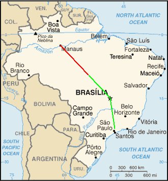
Map of Brazil showing the presumed flight paths of Gol Transportes Aéreos Flight 1907 and the Embraer Legacy 600 aircraft that it collided with to the crash site
- Red line = Gol Transportes Aéreos Flight 1907's flight path
- Green line = Embraer Legacy 600's flight path
[edit] Licensing
 |
Permission is granted to copy, distribute and/or modify this document under the terms of the GNU Free Documentation License, Version 1.2 or any later version published by the Free Software Foundation; with no Invariant Sections, no Front-Cover Texts, and no Back-Cover Texts. Subject to disclaimers. Asturianu | Български | Català | Deutsch | English | Español | Français | Gaeilge | Italiano | 한국어 | 日本語 | Polski | Português | Română | Türkçe | +/- |
File history
Click on a date/time to view the file as it appeared at that time.
| Date/Time | Dimensions | User | Comment | |
|---|---|---|---|---|
| current | 17:21, 6 October 2006 | 330×354 (34 KB) | Xamã | (Original was Br-map.gif from WikiCommmons, placed crash coords 10.29S 53.15W, drew lines between Sao Paulo, Manaus and Brasilia, to crash coord location, per GoogleMaps as reference ) |
File links
The following pages on the English Wikipedia link to this file (pages on other projects are not listed):

