Image:BOS airfield map.png
From Wikipedia, the free encyclopedia
No higher resolution available.
BOS_airfield_map.png (387 × 594 pixels, file size: 101 KB, MIME type: image/png)
| | This is a file from the Wikimedia Commons. The description on its description page there is shown below.
|
Transwiki approved by: w:en:User:Dmcdevit
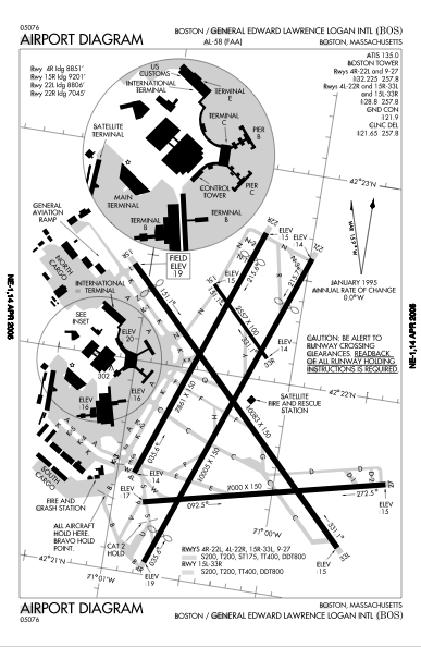
This image was copied from wikipedia:en. The original description was:
FAA diagram of w:en:Logan International Airport. Current as of April 2005. Older (and slightly more legible) version at w:en:Image:BOS map.png.
| This image is a work of a Federal Aviation Administration employee, taken or made during the course of an employee's official duties. As works of the U.S. federal government, all FAA images are in the public domain. |  |
[edit] File history
| date/time | username | resolution | size | edit summary |
|---|---|---|---|---|
| 19:52, 30 April 2005 | w:en:User:RandomWalk | 387×594 | 101 KB | FAA diagram of <a href="/wiki/Logan_International_Airport" title="Logan International Airport">Logan International Airport</a>. Current as of April 2005. {{PD}} |
[edit] Image description page history
| link | date/time | username | edit summary |
|---|---|---|---|
| http://en.wikipedia.org/w/index.php?title=Image:BOS_airfield_map.png&redirect=no&oldid=17465015 | 06:05, 16 September 2007 | w:en:User:Dmcdevit | |
| http://en.wikipedia.org/w/index.php?title=Image:BOS_airfield_map.png&redirect=no&oldid=17465015 | 11:03, 1 May 2005 | w:en:User:SPUI | |
| http://en.wikipedia.org/w/index.php?title=Image:BOS_airfield_map.png&redirect=no&oldid=13078935 | 11:03, 1 May 2005 | w:en:User:SPUI | |
| http://en.wikipedia.org/w/index.php?title=Image:BOS_airfield_map.png&redirect=no&oldid=13078929 | 01:39, 1 May 2005 | w:en:User:ChrisRuvolo | |
| http://en.wikipedia.org/w/index.php?title=Image:BOS_airfield_map.png&redirect=no&oldid=13058806 | 19:52, 30 April 2005 | w:en:User:RandomWalk | (FAA diagram of <a href="/wiki/Logan_International_Airport" title="Logan International Airport">Logan International Airport</a>. Current as of April 2005. {{PD}}) |
File history
Click on a date/time to view the file as it appeared at that time.
| Date/Time | Dimensions | User | Comment | |
|---|---|---|---|---|
| current | 13:23, 16 September 2007 | 387×594 (101 KB) | BetacommandBot | (Transwiki approved by: w:en:User:Dmcdevit This image was copied from wikipedia:en. The original description was: FAA diagram of w:en:Logan International Airport. Current as of April 2005. Older (and slightly more legible) version at [[w:en::Imag) |
File links
No pages on the English Wikipedia link to this file. (Pages on other projects are not counted.)

