Image:Bishop tuff.jpg
From Wikipedia, the free encyclopedia
No higher resolution available.
Bishop_tuff.jpg (800 × 500 pixels, file size: 139 KB, MIME type: image/jpeg)
| | This is a file from the Wikimedia Commons. The description on its description page there is shown below.
|
[edit] Summary
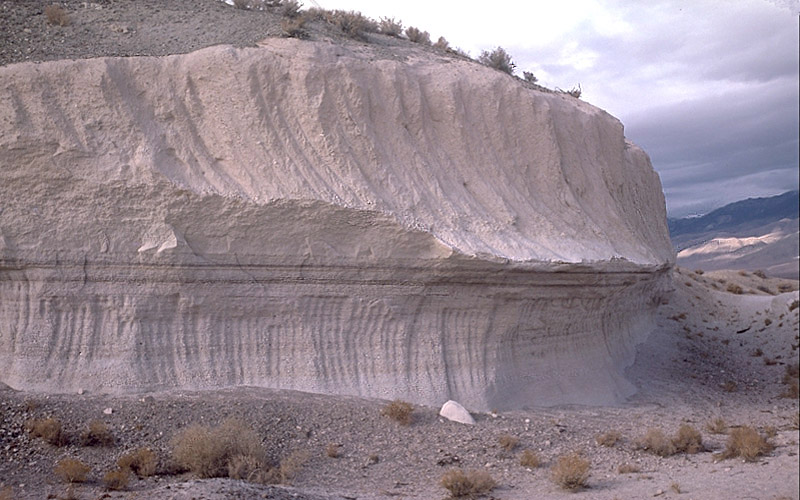
| Description |
Photo showing two layers of Bishop tuff, eastern California, United States |
|---|---|
| Source | |
| Date |
1987-10-29 |
| Author |
Roy A. Bailey |
| Permission (Reusing this image) |
see below |
USGS Caption: This outcrop is exposed in a rock quarry in Chalfant Valley about 25 km southwest of Long Valley Caldera. The two main units of the Bishop Tuff deposit are visible here: (1) the lower 5 m of the section consists of the pumice that fell to the ground (airfall pumice) downwind from the eruption; and (2) the upper 5-6 m of the section consists of the basal part of the pyroclastic flows that swept at hurricane speed away from the eruption. The thin dark "layers" just below the contact between the units are stains from an ancient groundwater table (manganese oxide stains).
[edit] Licensing
| This image is in the public domain because it contains materials that originally came from the United States Geological Survey, an agency of the United States Department of Interior. For more information, see the official USGS copyright policy |
|
File history
Click on a date/time to view the file as it appeared at that time.
| Date/Time | Dimensions | User | Comment | |
|---|---|---|---|---|
| current | 04:58, 15 April 2007 | 800×500 (139 KB) | Hike395 | ({{Information |Description = Photo showing two layers of Bishop tuff, eastern California, United States |Source = http://lvo.wr.usgs.gov/gallery/30714277-048_caption.html |Date = 1987-10-29 |Author = Roy A. Bailey |Permission = }} USGS) |

