Image:Bergen Hardangerfjord.png
From Wikipedia, the free encyclopedia
No higher resolution available.
Bergen_Hardangerfjord.png (511 × 506 pixels, file size: 97 KB, MIME type: image/png)
| | This is a file from the Wikimedia Commons. The description on its description page there is shown below.
|
[edit] Summary
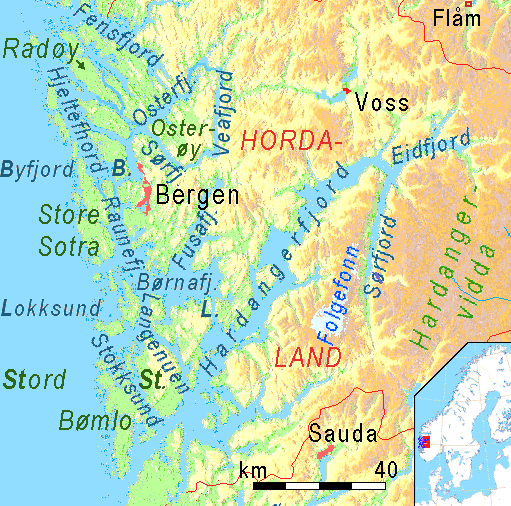
| Description |
Physical map of Fjords and Sunds around Bergen and Hardangerfjord, showing the position of Fensfjord, Hjeltefjord, Osterøy, Osterfjord, Vedfjord, Sørfjord, Raunefjord,Børnafjord,Lokksund,Langenuen, Stokksund and Bømlo, Hardangerfjord with Sørfjord and Eidfjord. |
|---|---|
| Source | No source specified. Please edit this image description and provide a source. |
| Date | |
| Author | |
| Permission (Reusing this image) |
see below |
| Other versions | Image:Bergen Stavanger Fjorde.png, prolonged by about 80 kilometers to the south |
[edit] Licensing
| This file is licensed under the Creative Commons Attribution ShareAlike 3.0 Unported License. In short: you are free to share and make derivative works of the file under the conditions that you appropriately attribute it, and that you distribute it only under a license compatible with this one.
العربية | Català | Česky | Deutsch | Ελληνικά | English | Esperanto | Español | Français | Italiano | עברית | 日本語 | 한국어 | Magyar | Nederlands | Plattdüütsch | Polski | Português | Русский | Svenska | Tiếng Việt | Українська | +/- |
File history
Click on a date/time to view the file as it appeared at that time.
| Date/Time | Dimensions | User | Comment | |
|---|---|---|---|---|
| current | 21:50, 30 January 2008 | 511×506 (97 KB) | Ulamm | |
| 15:19, 30 January 2008 | 511×506 (97 KB) | Ulamm | ||
| 20:08, 29 January 2008 | 511×506 (98 KB) | Ulamm | ||
| 14:12, 29 January 2008 | 511×506 (97 KB) | Ulamm | ||
| 14:08, 29 January 2008 | 511×506 (97 KB) | Ulamm | (== Summary == {{Information |Description= Physical map of Fjords and Sunds around Bergen and Hardangerfjord, showing the position of Fensfjord, Hjeltefjord, Osterøy, Osterfjord, Vedfjord, Sørfjord, Raunefjord,Børnafjord,Lokksund,Langenuen, Stokksund an) |
File links
The following pages on the English Wikipedia link to this file (pages on other projects are not listed):

