Baarle-Nassau
From Wikipedia, the free encyclopedia
| Baarle-Nassau | |
 |
|
| Country | Netherlands |
|---|---|
| Province | North Brabant |
| Area (2006) | |
| - Total | 76.30 km² (29.5 sq mi) |
| - Land | 76.27 km² (29.4 sq mi) |
| - Water | 0.03 km² (0 sq mi) |
| Population (1 January 2007) | |
| - Total | 6,668 |
| - Density | 87/km² (225.3/sq mi) |
| Source: CBS, Statline. | |
| Time zone | CET (UTC+1) |
| - Summer (DST) | CEST (UTC+2) |
Baarle-Nassau (pronunciation ) is a municipality and a town in the southern Netherlands.
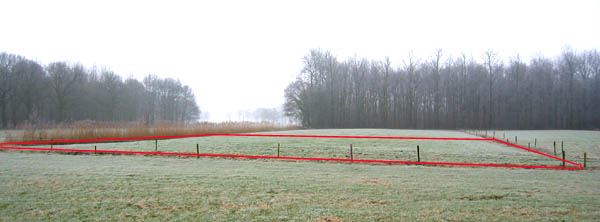
It is closely linked, with complicated borders, to the Belgian exclaves of Baarle-Hertog. Baarle-Hertog consists of 26 separate pieces of land. Apart from the main piece (called Zondereigen) located north of the Belgian town of Merksplas, there are 22 Belgian exclaves in the Netherlands and three other pieces on the Dutch-Belgian border. There are also seven Dutch exclaves located within the Belgian exclaves. Six of them are located in the largest one and a seventh in the second-largest one. An eighth Dutch exclave lies in Zondereigen. The smallest enclave, H22, measures 2,632 square metres.
The complex border situation is a result of a number of equally complex medieval treaties, agreements, land-swaps and sales between the Lords of Breda and the Dukes of Brabant. Generally speaking, predominantly agricultural or built environments became constituents of Brabant, other parts devolved to Breda. These distributions were ratified and clarified as a part of the borderline settlements arrived at during the Treaty of Maastricht in 1843.

|

[edit] Population centres
[edit] External links
- Official Web site Baarle-Nassau (in Dutch)
- Official Web site Baarle-Hertog (in Dutch)
- maps
- Photograph of the smallest enclave
- Baarle-Nassau / Baarle-Hertog (with maps)
- Photos from Baarle-Nassau/Hertog
- English Website about the Baarle Enclaves / with maps
- Dutch pages about Baarle-Hertog and Baarle-Nassau / with maps
|
|||||||||||

