Image:Australia cadastral subdivsions counties.png
From Wikipedia, the free encyclopedia
No higher resolution available.
Australia_cadastral_subdivsions_counties.png (500 × 468 pixels, file size: 39 KB, MIME type: image/png)
| | This is a file from the Wikimedia Commons. The description on its description page there is shown below.
|
[edit] Summary
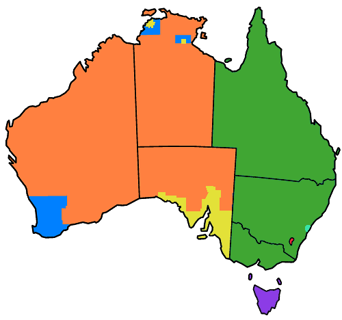
██ No counties, parishes or hundreds
██ Former counties, no further subdivisions
██ Counties, subdivided into hundreds
██ Counties, subdivided into parishes
██ Land Districts (formerly counties), subdivided into parishes, and formerly with hundreds. (Except King Island and Flinders Island, which were not part of counties, but are now land districts)
██ Formerly counties and parishes (ACT)
██ Counties, subdivided into parishes, and formerly with hundreds also (Cumberland)
Parts of Australia divided into counties for cadastral purposes, mostly this took place during the nineteenth century. (The line in South Australia is an approximation - this map shows counties in SA in 1886, but later others were added - not sure of exact location.) The ACT was once part of counties in NSW (Murray and Cowley) but no longer. Based on Golbez's GNU licenced map of Australia here
[edit] Licensing

File history
Click on a date/time to view the file as it appeared at that time.
| Date/Time | Dimensions | User | Comment | |
|---|---|---|---|---|
| current | 02:35, 2 May 2007 | 500×468 (39 KB) | Roke | (tasmanian counties renamed land districts) |
| 09:38, 18 April 2007 | 500×468 (39 KB) | Roke | (Reverted to earlier revision) | |
| 10:18, 7 April 2007 | 500×468 (37 KB) | Roke | ||
| 10:03, 7 April 2007 | 500×468 (39 KB) | Roke | (== Summary == {{legend|#ff8040|No counties, parishes or hundreds}} {{legend|#0080ff|Counties, but no further subdivisions}} {{legend|#e3e138|Hundreds}} {{legend|#40a633|Parishes}} {{legend|#f62840|Formerly parishes (ACT)) |

