Image:ArmeniaNumbered.png
From Wikipedia, the free encyclopedia
Size of this preview: 594 × 600 pixels
Full resolution (750 × 757 pixels, file size: 81 KB, MIME type: image/png)
| | This is a file from the Wikimedia Commons. The description on its description page there is shown below.
|
 A vector version of this image (SVG) is available. For more information about vector graphics, read about Commons transition to SVG. Български | Deutsch | English | Español | Français | Galego | עברית | Magyar | Bahasa Indonesia | Italiano | 日本語 | 한국어 | Lietuvių | Polski | Português | Русский | Српски / Srpski | Українська | 中文(简体) | 中文(繁體) | +/- |
 |
[edit] Summary
Español: Mapa de las provincias de Armenia.
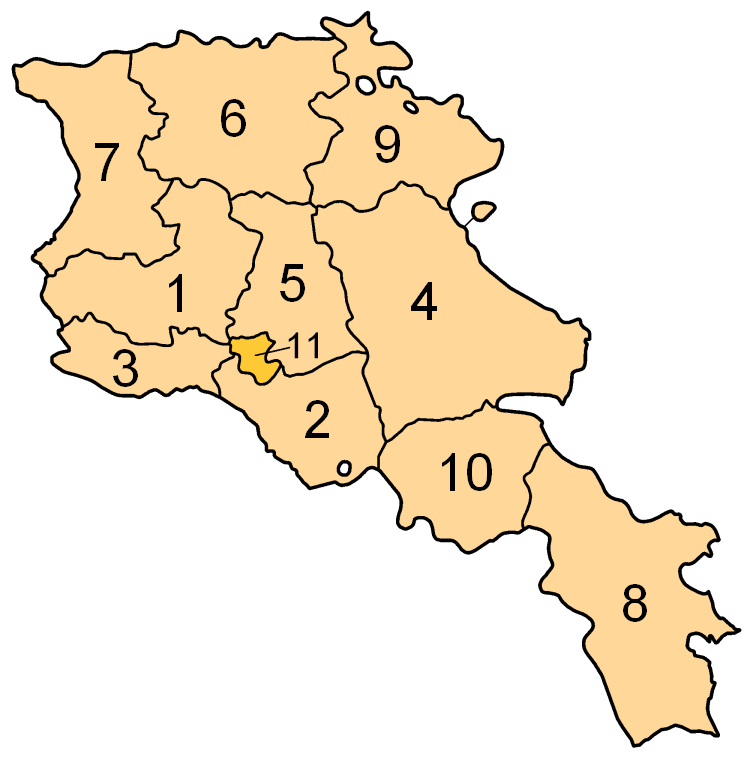
Subdivisions of Armenia. Map created by w:en:user:Golbez. Coloured by w:en:user:Aivazovsky.
[edit] Licensing

Image shows the eleven administrative subdivisions of Armenia:
- Aragatsotn (Արագածոտնի)
- Ararat (Արարատի)
- Armavir (Արմավիրի)
- Gegharkunik (Գեղարքունիքի)
- Kotayk (Կոտայքի)
- Lori (Լոռու)
- Shirak (Շիրակի)
- Syunik (Սյունիքի)
- Tavush (Տավուշի)
- Vayots Dzor (Վայոց Ձորի)
- Yerevan (Երևան) - special administrative status
File history
Click on a date/time to view the file as it appeared at that time.
| Date/Time | Dimensions | User | Comment | |
|---|---|---|---|---|
| current | 01:57, 30 July 2006 | 750×757 (81 KB) | Aivazovsky | (Smaller numbers work better.) |
| 20:37, 29 July 2006 | 750×757 (89 KB) | Aivazovsky | (Better version.) | |
| 08:40, 30 March 2005 | 300×303 (29 KB) | Kocio | (straight from http://en.wikipedia.org/wiki/Image:ArmeniaNumbered.png, {{GFDL}}) |
File links
No pages on the English Wikipedia link to this file. (Pages on other projects are not counted.)

