Image:Amphoe Phitsanulok.png
From Wikipedia, the free encyclopedia
No higher resolution available.
Amphoe_Phitsanulok.png (520 × 590 pixels, file size: 17 KB, MIME type: image/png)
| | This is a file from the Wikimedia Commons. The description on its description page there is shown below.
|
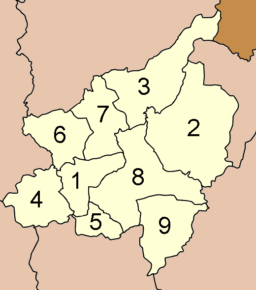
Map of Phitsanoluk province, Thailand, with the districts numbered
- Mueang Phitsanulok (อำเภอเมืองพิษณุโลก)
- Nakhon Thai (อำเภอนครไทย)
- Chat Trakan (อำเภอชาติตระการ)
- Bang Rakam (อำเภอบางระกำ)
- Bang Krathum (อำเภอบางกระทุ่ม)
- Phrom Phiram (อำเภอพรหมพิราม)
- Wat Bot (อำเภอวัดโบสถ์)
- Wang Thong (อำเภอวังทอง)
- Noen Maprang (อำเภอเนินมะปราง)

| This file is licensed under Creative Commons Attribution ShareAlike 1.0 License |
File history
Click on a date/time to view the file as it appeared at that time.
| Date/Time | Dimensions | User | Comment | |
|---|---|---|---|---|
| current | 12:45, 3 January 2007 | 520×590 (17 KB) | Ahoerstemeier | (Laos was not in different color) |
| 11:47, 11 April 2005 | 520×587 (51 KB) | Ahoerstemeier | (Map of Phitsanoluk province, Thailand, with the districts numbered {{GFDL}} {{cc-by-sa}} Category:Maps of Phitsanoluk Phitsanoluk) |
File links
The following pages on the English Wikipedia link to this file (pages on other projects are not listed):

