Image:Amphoe Nakhon Ratchasima.png
From Wikipedia, the free encyclopedia
No higher resolution available.
Amphoe_Nakhon_Ratchasima.png (415 × 450 pixels, file size: 32 KB, MIME type: image/png)
| | This is a file from the Wikimedia Commons. The description on its description page there is shown below.
|
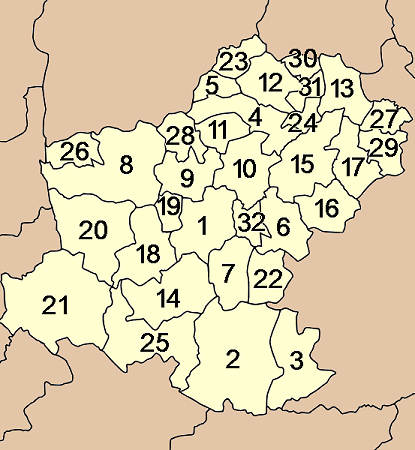
Map of Nakhon Ratchasima province, Thailand, with the districts (Amphoe) numbered.
- Mueang Nakhon Ratchasima (อำเภอเมืองนครราชสีมา)
- Khon Buri (อำเภอครบุรี)
- Soeng Sang (อำเภอเสิงสาง)
- Khong (อำเภอคง)
- Ban Lueam (อำเภอบ้านเหลื่อม)
- Chakkarat (อำเภอจักราช)
- Chok Chai (อำเภอโชคชัย)
- Dan Khun Thot (อำเภอด่านขุนทด)
- Non Thai (อำเภอโนนไทย)
- Non Sung (อำเภอโนนสูง)
- Kham Sakaesaeng (อำเภอขามสะแกแสง)
- Bua Yai (อำเภอบัวใหญ่)
- Prathai (อำเภอประทาย)
- Pak Thong Chai (อำเภอปักธงชัย)
- Phimai (อำเภอพิมาย)
- Huai Thalaeng (อำเภอห้วยแถลง)
- Chum Phuang (ชุมพวง)
- Sung Noen (อำเภอสูงเนิน)
- Kham Thale So (อำเภอขามทะเลสอ)
- Sikhio (อำเภอสีคิ้ว)
- Pak Chong (อำเภอปากช่อง)
- Nong Bun Mak (อำเภอหนองบุญมาก)
- Kaeng Sanam Nang (อำเภอแก้งสนามนาง)
- Non Daeng (อำเภอโนนแดง)
- Wang Nam Khiao (อำเภอวังน้ำเขียว)
- Thepharak (อำเภอเทพารักษ์)
- Mueang Yang (อำเภอเมืองยาง)
- Phra Thong Kham (อำเภอพระทองคำ)
- Lam Thamenchai (อำเภอลำทะเมนชัย)
- Bua Lai (อำเภอบัวลาย)
- Sida (อำเภอสีดา)
- Chaloem Phra Kiat (อำเภอเฉลิมพระเกียรติ)

| This file is licensed under Creative Commons Attribution ShareAlike 1.0 License |
File history
Click on a date/time to view the file as it appeared at that time.
| Date/Time | Dimensions | User | Comment | |
|---|---|---|---|---|
| current | 21:18, 10 August 2005 | 415×450 (32 KB) | Ahoerstemeier | (Map of Nakhon Ratchasima province, Thailand, with the districts (Amphoe) numbered. {{GFDL}} {{cc-by-sa}} Nakhon Ratchasima Category:Maps of Nakhon Ratchasima) |
File links
The following pages on the English Wikipedia link to this file (pages on other projects are not listed):

