Image:Alegeri1946.png
From Wikipedia, the free encyclopedia
No higher resolution available.
Alegeri1946.png (500 × 389 pixels, file size: 56 KB, MIME type: image/png)
| | This is a file from the Wikimedia Commons. The description on its description page there is shown below.
|
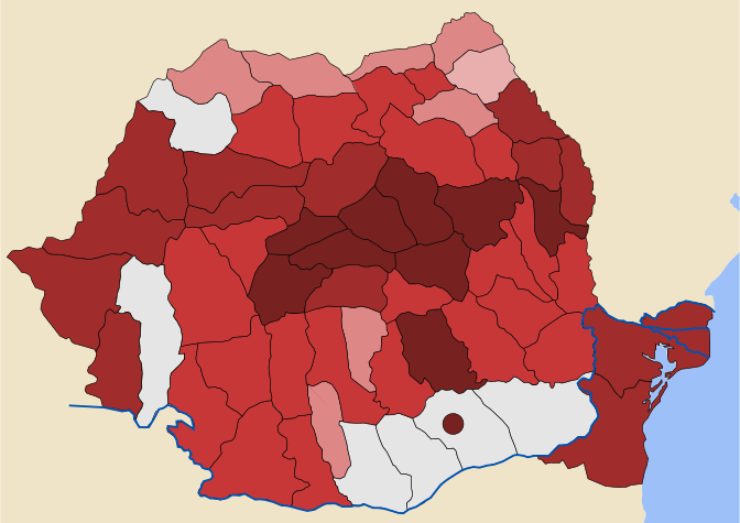
[edit] Legend
| ——— | 60 % and over Bloc of Democratic Parties and its UPM allies |
| ——— | 50% — 60% |
| ——— | 30% — 50% |
| ——— | 15% — 30% |
| ——— | 00% — 15% |
| ——— | unknown or undisclosed |
[edit] Summary
| Description |
English: Romania, 1946 Elections - Possible Results per county; based on informations from Alegerile parlamentare din noiembrie '46: guvernul procomunist joacă şi câştigă. Ilegalităţi flagrante, rezultat viciat (Parlamentary Elections from November '46: procommunist governement plays and wins. Obvious Illegalities, Vicious Result) by Petre Ţurlea, from Dosarele Istoriei (History Files), 11 (51)/2000, p. 35-36 citing in turn a confidential document of Romanian Communist Party.
Română: Romania, Alegerile din 1946 - rezultate posibile pe judeţe; bazată pe informaţii din Alegerile parlamentare din noiembrie '46: guvernul comunist joacă şi câştigă. Ilegalităţi flagrante, rezultat viciat. de Petre Ţurlea, din Dosarele Istoriei, 11 (51)/2000, p. 35-36, citând la rândul său un document confidenţial al Partidului Comunist Român.
|
|---|---|
| Source | |
| Date |
January 24, 2007 |
| Author |
original work by Dahn, updated version by Cornel Ilie (made with Inkscape) |
| Permission (Reusing this image) |
Public Domain |
| Other versions | January 19, 2007 original work by Dahn (made with Pixia), based on a Public Domain work Judeţele României Interbelice |
[edit] Licensing
| I, the copyright holder of this work, hereby release it into the public domain. This applies worldwide. In case this is not legally possible: Afrikaans | Alemannisch | Aragonés | العربية | Asturianu | Български | Català | Česky | Cymraeg | Dansk | Deutsch | Eʋegbe | Ελληνικά | English | Español | Esperanto | Euskara | Estremeñu | فارسی | Français | Galego | 한국어 | हिन्दी | Hrvatski | Ido | Bahasa Indonesia | Íslenska | Italiano | עברית | Kurdî / كوردی | Latina | Lietuvių | Latviešu | Magyar | Македонски | Bahasa Melayu | Nederlands | Norsk (bokmål) | Norsk (nynorsk) | 日本語 | Polski | Português | Ripoarisch | Română | Русский | Shqip | Slovenčina | Slovenščina | Српски / Srpski | Svenska | ไทย | Tagalog | Türkçe | Українська | Tiếng Việt | Walon | 中文(简体) | 中文(繁體) | zh-yue-hant | +/- |
File history
Click on a date/time to view the file as it appeared at that time.
| Date/Time | Dimensions | User | Comment | |
|---|---|---|---|---|
| current | 16:51, 24 January 2007 | 500×389 (56 KB) | Cornel commons | (Remake of previous version, paying more attention to Norden Boundaries.) |
| 07:11, 24 January 2007 | 500×389 (57 KB) | Cornel commons | (New version of this file, based on previous version (replaced) and commons:Image:Romania_1930,_Administrative_Map.svg) | |
| 14:58, 19 January 2007 | 998×692 (20 KB) | Dahn | (Created in January 2007 by Dahn, using Pixia. Possible results of the 1946 elections in Romania per county, based on information from Petre Ţurlea, "Alegerile parlamentare din noiembrie '46: guvernul procomunist joacă şi câştigă. Ileg) |

