Image:Afghanistan map.png
From Wikipedia, the free encyclopedia
No higher resolution available.
Afghanistan_map.png (331 × 355 pixels, file size: 21 KB, MIME type: image/png)
| | This is a file from the Wikimedia Commons. The description on its description page there is shown below.
|
 It is recommended that the other file be used. Alemannisch | العربية | Български | Česky | Dansk | Deutsch | English | Ελληνικά | Esperanto | Español | Français | Galego | עברית | हिन्दी | Magyar | Bahasa Indonesia | Italiano | 日本語 | 한국어 | Lietuvių | Nederlands | Norsk (nynorsk) | Polski | Português | Română | Русский | Slovenščina | Српски / Srpski | Svenska | Türkçe | 中文(简体) | 中文(繁體) | +/- |
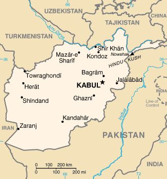
Map of Afghanistan.
| This image is in the public domain because it contains materials that originally came from the United States Central Intelligence Agency's World Factbook.
Deutsch | English | Español | Français | 日本語 | Nederlands | 한국어 | Português | தமிழ் | Magyar | +/- |
 |
File history
Click on a date/time to view the file as it appeared at that time.
| Date/Time | Dimensions | User | Comment | |
|---|---|---|---|---|
| current | 17:39, 17 April 2005 | 331×355 (21 KB) | Shauni | (Map of Afghanistan. This image is a map or flag taken and/or modified from the Central Intelligence Agency's World Factbook. Under United States copyright law, all information and images from the World Factbook are public domain. ) |
File links
The following pages on the English Wikipedia link to this file (pages on other projects are not listed):

