Image:1922 New England routes.jpg
From Wikipedia, the free encyclopedia
No higher resolution available.
1922_New_England_routes.jpg (255 × 580 pixels, file size: 65 KB, MIME type: image/jpeg)
| | This is a file from the Wikimedia Commons. The description on its description page there is shown below.
|
|
|
This media file is in the public domain in the United States. This applies to U.S. works where the copyright has expired, often because its first publication occurred prior to January 1, 1923. See this page for further explanation.
|
|
|
Deutsch | English | Español | Français | Gaeilge | Galego | Italiano | Nederlands | 中文(简体) | +/- |
||
|
|
This image might not be in the public domain outside of the United States (this especially applies in Canada, China (not Hong Kong, Macao, or Taiwan Area), Germany, Mexico, and Switzerland). The creator and year of publication are essential information and must be provided. See Wikipedia:Public domain and Wikipedia:Copyrights for more details. |
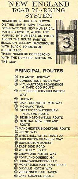
Section of a 1922 Rand McNally map, Tydol Trails: New England Trails Road Marking System and Color Band Route. Cropped from the maps at http://www.usm.maine.edu/maps/exhibit9/showing.html (available here as Image:1922 New England road map 1.jpg and Image:1922 New England road map 2.jpg.
File history
Click on a date/time to view the file as it appeared at that time.
| Date/Time | Dimensions | User | Comment | |
|---|---|---|---|---|
| current | 01:51, 5 March 2005 | 255×580 (65 KB) | SPUI | ({{PD}}Section of a 1922 Rand McNally map, ''Tydol Trails: New England Trails Road Marking System and Color Band Route''. Cropped from the maps at http://www.usm.maine.edu/maps/exhibit9/showing.html (available here as [[:Image:1922 New England road map 1.j) |
File links
The following pages on the English Wikipedia link to this file (pages on other projects are not listed):

