Image:Aegean Sea and Anatolian Plates map-fr.png
From Wikipedia, the free encyclopedia
No higher resolution available.
Aegean_Sea_and_Anatolian_Plates_map-fr.png (552 × 291 pixels, file size: 189 KB, MIME type: image/png)
| | This is a file from the Wikimedia Commons. The description on its description page there is shown below.
|
| Description |
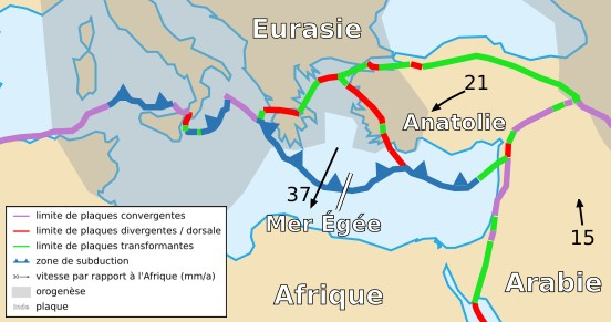
Français : Carte des plaques de la Mer Egée et anatolienne
English: Map of the Aegean Sea and Anatolian Plates
|
||
|---|---|---|---|
| Source |
Cropped version by myself of Image:Tectonic_plates_boundaries_detailed-fr.svg created by Sting under CC-BY-SA |
||
| Date |
18/11/2006 |
||
| Author | |||
| Permission (Reusing this image) |
|
||
| Other versions | Scaled version of  |
File history
Click on a date/time to view the file as it appeared at that time.
| Date/Time | Dimensions | User | Comment | |
|---|---|---|---|---|
| current | 22:06, 18 November 2006 | 552×291 (189 KB) | Rémih | ({{Information |Description={{fr|Carte des plaques de la Mer Egée et anatolienne}}{{en|Map of the Aegean Sea and Anatolian Plates}} |Source=Cropped version by myself of Image:Tectonic_plates_boundaries_detailed-fr.svg created by Sting ) |
File links
The following pages on the English Wikipedia link to this file (pages on other projects are not listed):

